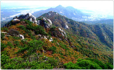
Foliage of Suraksan Mountain, the guardian mountain of Seoul
At 638m above sea level, it is called one of the four famous mountains near Seoul along with Bukhansan, Dobongsan, and Gwanaksan. Suraksan, which is mostly made up of broadleaf trees, also presents a spectacular sight in the fall when the maple leaves change color to orange and yellow.
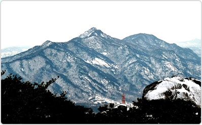
Buddha wearing a pine tree, snowy scenery of Bulamsan Mountain
It is included in the first course of the Seoul Trail along with Mt. Surak, and it has a natural yard, a footpath, and an ecological learning center created by our district, so we can promote our district as an ‘eco-friendly city where nature and humans coexist.’ In particular, the snowy scenery is beautiful, so many famous mountaineering clubs visit Mt. Bul-am in the winter.
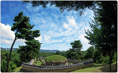
Taereung, UNESCO World Heritage Site
It has high preservation value as it is designated as a UNESCO World Cultural Heritage. In addition, the Taereung Forest Trail, which connects the Joseon Royal Tombs Exhibition Hall to Taereung, is home to various species of trees, and its scenery is so excellent that it has been designated as a healing spot by the Seoul Metropolitan Government
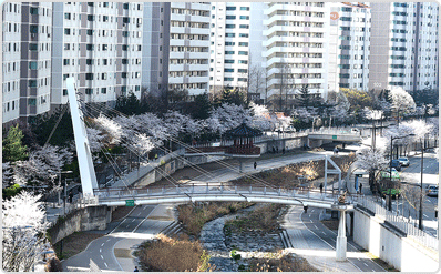
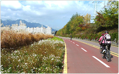
Danghyeoncheon Cherry Blossom Road
The Dang-hyeoncheon Cherry Blossom Road, which stretches from Dang-hyeon 1 Bridge to Saesak Bridge, has established itself as the representative cherry blossom road of our district. In addition, Dang-hyeoncheon is well-developed as a walking and bicycle course for residents, so many families visit, and the Nowon Lantern Festival is held every year, providing attractions for residents.
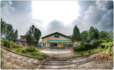
Gyeongchun Line Forest Road and Hwarangdae Station
Hwarangdae Station, which has a high symbolic value as the ‘Seoul's Last Simple Station’, presents a beautiful scenery with wildflowers in full bloom around the railroad tracks and the sunset at dusk. It is expected that its usability will increase when a railroad museum is built, and the Gyeongchun Line Forest Trail, which passes the old Hwarangdae Station and continues along the railroad tracks, is loved as a walking trail by residents.
Nowon Reed Forest of Jungnangcheon
Our district, which has been used as a transportation route connecting the south and the north since ancient times, has developed wide plains and reed fields, and has been using the name of the district as “Reed No (蘆) Plain Won (原)” since the Goryeo Dynasty. The reed forest, which is about 1km long and has been created along the Jungnangcheon Stream within our district, will be a place that can highlight the symbolism of our district.
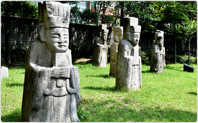
Joseon Dynasty Tombs of Choansan Mountain
The Choansan Tomb Cluster, designated as Historic Site No. 440, is a unique tourist resource in our district where the tombstones and steles of Joseon Dynasty officials and scholars are scattered. In addition, when the Choansan Agisomang Road is created, its usability can be increased by linking it with it.
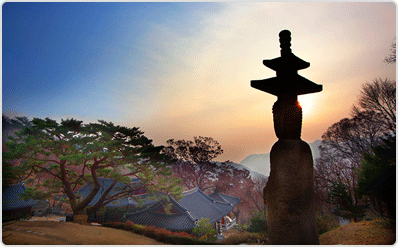
Sunrise at Hakrimsa Temple, Suraksan Mountain
Hakrimsa Temple, said to have been founded by Monk Wonhyo in the 11th year of King Munmu of Silla (671), is located on the 7th ridge from Dosolbong Peak to Gwiimbong Peak on the southern side of Suraksan Mountain, and its grounds are cozy as if they are embracing a crane. As you can see in the photo, the sunrise seen from Hakrimsa Temple on Suraksan Mountain is a beautiful sight as the temple and sunrise are in harmony.
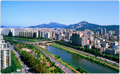
Nowon Panoramic
Our district has famous mountains such as Suraksan and Bul-amsan in the background, and natural rivers such as Jungnangcheon and artificial apartments and roads are in harmony. In particular, our district has a green space ratio of 62.9% of the total area of the district, which is the highest ratio among the 14 autonomous districts north of the Han River, allowing us to see the nature-friendly and green appearance of our district at a glance.